In the urgent battle against climate change and environmental degradation, Nature Based Solutions (NBS) such as reforestation and conservation projects have emerged as critical strategies. These initiatives not only mitigate carbon emissions but also support biodiversity, economic development, and local communities. Now, with the integration of advanced technology, digitising these projects is revolutionising the way companies implement and monitor their sustainability efforts while providing new opportunities for project developers to streamline their operations and amplify their impact.
For companies striving to integrate NBS into their sustainability strategies, digitisation offers a myriad of advantages. Firstly, it enhances transparency and accountability by providing real-time monitoring and reporting of project progress. Through satellite imagery, drones, and other remote sensing technologies, companies can precisely track reforestation rates and ecosystem health, ensuring that their investments yield tangible environmental benefits.
A Solution for Companies and Project Developers
Furthermore, this “digital approach” empowers companies to engage stakeholders and communicate their sustainability efforts effectively. Through interactive maps, multimedia content, and social media integration, they can showcase project impacts, foster community involvement, and build a brand reputation as environmental stewards. This transparent and engaging approach not only enhances corporate credibility but also inspires broader societal action towards environmental conservation.
On the other hand, for project developers seeking to establish NBS initiatives, digitisation presents a host of opportunities to streamline project development and management. Digitisation, not only makes it easier to monitor the scientific indices of projects but also allows them to be narrated and visualised through maps, images and data, facilitating access to funding and partnerships by providing robust evidence of project viability and impact. With detailed monitoring and evaluation systems in place, developers can attract investment from philanthropic organizations, impact investors, and corporations eager to support sustainable development goals.
Green Future Project Platform, in collaboration with Orbify, represents a paradigm shift in the digitisation of Nature Based Solutions. By leveraging the power of geospatial data and satellite imagery analysis, the platform empowers stakeholders to accelerate progress towards a more sustainable and resilient future.
At the heart of the Green Future Project Platform lies a commitment to utilising the power of data and technology to drive positive environmental outcomes. Through strategic collaboration with Orbify, the platform integrates state-of-the-art Geospatial Data Platform (GDP) capabilities, coupled with analyses from three distinct satellites.
Let's dive into environmental impact assessment and see how Orbify makes measuring and monitoring environmental projects incredibly precise and efficient.
Understanding Orbify Technology
Orbify is an innovative technology in the world of environmental impact assessment. By harnessing the power of satellite imagery and artificial intelligence, Orbify enables users to measure and monitor the impact of environmental projects with unprecedented accuracy and efficiency.
The technology behind Orbify relies on a Geospatial Data Platform (GDP) coupled with analyses from three distinct satellite imagery sources: Optical, LiDAR, and SAR. These satellites provide high-resolution data, allowing for comprehensive analysis of environmental changes. Optical imagery from sources like the European Space Agency Copernicus Sentinel-2 and NASA's Landsat Program offers deep insights into spectral resolution, while LiDAR and SAR enable precise measurements of forest canopy height and surface elevation.
The three satellites, combined with a forest Machine Learning model, can estimate the forest cover in the area of interest, making Orbify methodology an essential tool to gain valuable information and data into forest dynamics.
Nature Based Solutions need a strong monitoring program to be effective and ensure its success. In this context, satellite imagery represents an essential tool. Offering remote sensing and machine learning models, satellites can collect all the key data of a specific project, to support the different stages of a project implementation from the Project Design phase, to the funding and monitoring one.
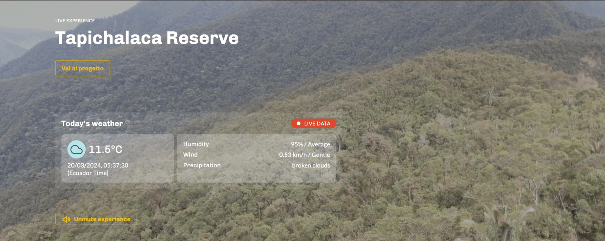
The Importance of Transparent Communication
Transparent communication is the flagstone of effective sustainability initiatives. Orbify facilitates this transparency by providing accurate and updated data on the progress of sustainability projects.
Let's delve into some case studies to understand how Orbify technology is revolutionising sustainability communication across various project typologies:
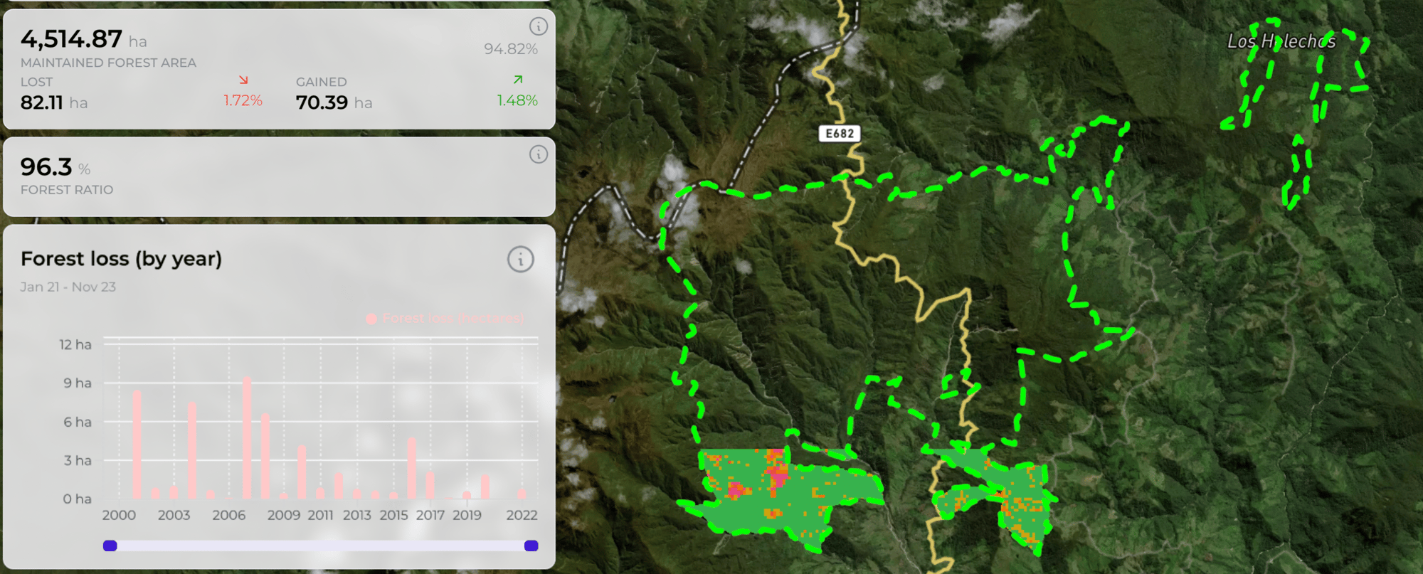
Forest Conservation
Forest Conservation projects can be analysed by setting up a group of components which allow monitoring of how an area is responding to the conservation efforts and the planned project activities.
- Forest Loss, which quantifies annual forest cover loss, with a focus on the transition from forest to non-forest states and is defined as a stand-replacement disturbance. This refers to events that can cause loss of tree cover and the conversion of the assessed areas into non-forest ones.
-
Forest Ratio, to provide forest cover in terms of a percentage: if the percentage of forest cover decreases, it is a clear signal of deforestation risk in place.
-
Forest maintained/ gained / lost allows the visualization of different coloured layers, to concretely see on the project area map the portion of forest cover that is maintained, gained or lost.
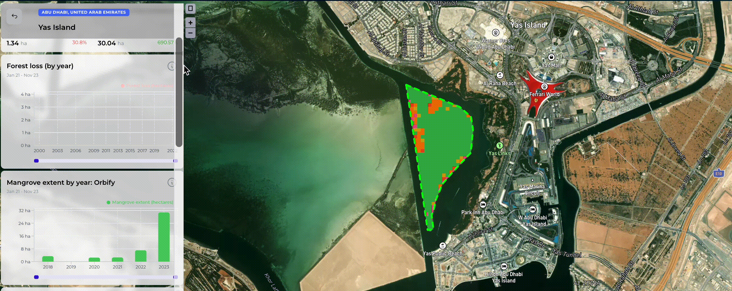
Mangroves Restoration
Being a particular tree species, mangroves need a specific mix of components calibrated to their characteristics. Mangrove Reforestation projects, above all, should be assessed using key data to understand the implemented activities’ progress and promptly act where necessary.
Orbify provides a mangrove-dedicated set of components which include:
- The Orbify Mangrove Monitoring, a tool to assess annual mangrove cover ensuring that seasonal fluctuations are accounted for. It has been designed to specifically distinguish between mangroves and non-mangrove vegetation types, including mangrove recovery rates.
- Mangrove extent by year, showing how much land is covered by mangroves and thus allowing a quick comparison of the cover growth extent over the years.
- Mangrove above-ground biomass is a dataset that provides an estimate of the biomass capacity of mangrove forests and is calculated by combining region-specific models, remote sensing data and three characteristics (tree height and diameter).
Carbon Offset Projects
Orbify offers remote sensing data optimes for REDD+ & ARR projects, highlighting essential elements such as Above Ground Biomass, Forest Loss Trends and Leakage Area Analysis. Leakage is one of the most important elements taken into consideration while evaluating a carbon offset project. This tool safeguards not only carbon sequestration and biodiversity benefits within a carbon offset project but also analyzes positive impacts across the entire landscape by shedding light on the potential risks of ripple effects that could influence ecosystems and their surroundings.

Driving change through transparency
In conclusion, the integration of advanced technology and digitisation into Nature Based Solutions (NBS) initiatives represents a pivotal step forward in the urgent battle against climate change and environmental degradation.
By leveraging innovation technologies, companies and project developers can not only measure the impact of their sustainability initiatives accurately but also communicate these efforts transparently to stakeholders. From forest conservation to carbon offset projects, GFP platform is paving the way for a more sustainable future. It's not just about showcasing achievements but also acknowledging challenges and demonstrating a commitment to continuous improvement.